
August is upon us so summer is winding down. Its time to plan out a few day trips to round out the summer adventures. We are fortunate to have a plethora of options for summer day trips in Western Wisconsin. The activities for the day trips can run the gamut from boating, to fishing, biking, hiking, canoeing, kayaking and bird watching. To jump start your search for some great summer day trips, I’ll describe some great day trips all of which are approximately hour or less driving time away.
The trail to adventure is open to anyone willing to head down the trail.
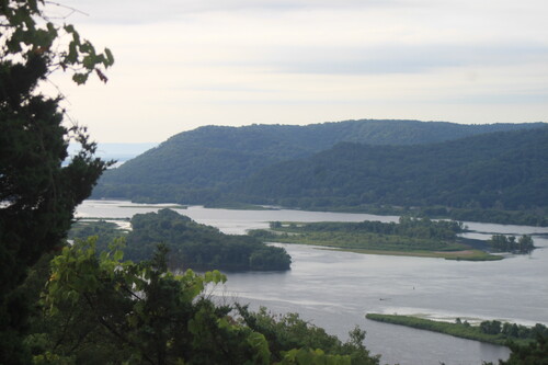
The Mississippi River with its beautiful bluffs, many channels and islands is a great place for day long adventures
Mississippi River including Lake Pepin.
The Mississippi River is a haven for water sports. Fishing is one of the primary activities on the Big Muddy. There are numerous boat launches from Red Wing to Alma so accessing any part of the River is very convenient, The Mississippi has such a wide variety of fish that the angler needs to pick a species or two and then target that type of fish whether it be walleye, bass, panfish, northerns, catfish, or the many other species that call the Big Muddy home. Anglers can fish the big open waters of Lake Pepin, the strong currents of main channels, or meander about in the backwaters.
There are many great places for paddle sports adventures on the River. A popular area is the backwaters between Nelson and Wabasha. The Nelson-Trevino canoe trail is an approximately five-mile trail that winds around the backwaters both up and downstream of the Highway 25 causeway. This is a great paddle for anyone who wants to combine birding with paddling. The backwaters are also a great area to kayak fish. Another great float is to put in next to the bridge on Highway 35 where it crosses the Chippewa River and float down to the Mississippi then then down to Highway 25. One can take out on either the Wisconsin side under the big bridge or in Wabasha. One other option is to put in at Alma and ferry across the main channel and then explore the backwaters downstream from the dam. One very popular activity on the Mississippi River is to load up all the picnic gear in the boat, head out on the river, find an inviting sand bar, and spend the day relaxing on the sand bar.
Brunet Island State Park and Old Abe Trail.
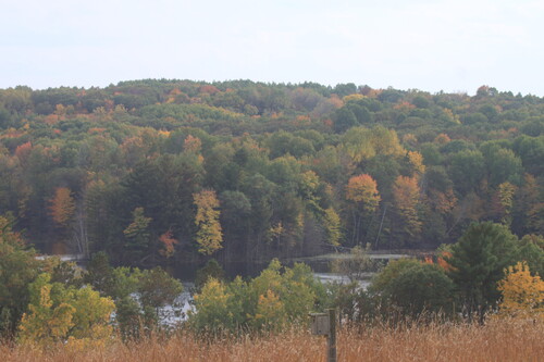
Brunet Island State Park is on the outskirts of Cornell, WI. As the name implies, much of the park consists of a big island with several adjacent smaller islands. There is also a large section of land behind the ranger station. The Cornell Flowage surrounds the islands and is formed by a dam immediately downstream from the park and the confluence of the Chippewa and Fisher Rivers. The park has a beautiful picnic ground that runs along the lake shore for a long ways. The swimming beach is adjacent to the largest portion of the picnic grounds. The water in the Cornell Flowage is always refreshingly cool. One of the old magnificent CCC-built picnic shelters is near the beach. If picnicking with the crowd is not your adventure, there are many more secluded tables along the lake shore. The Park has two major sets of trails. One set of trails is on the islands and the other is on the mainland. The mainland trails begin near the ranger station and make a series of loops up and down a series of hills and valleys. It's fairly typical glacial moraine terrain. The other trail system is on the islands. The longest trail makes a big loop through the center of the main island. Several other shorter tails have trailheads on the road loop that runs around the park.
The islands form many small waterways that are perfect for exploring by canoe and kayak. The flowage is also a great place to paddleboard. The fishing is good. Musky, Panfish, Largemouth Bass, Smallmouth Bass, Northern Pike, Walleye, Sturgeon, and Catfish all reside in the lake.
The Old Abe state trail begins in the park and runs to Chippewa Falls. It's a 22 mile ride to Chippewa Falls. Jim Falls is 10 miles down the trail from Cornell. The section of the trail from Cornell to Jim Falls runs along the Chippewa and is the most scenic portion of this trail. Information on Brunet Island State Park can be found at this link https://dnr.wisconsin.gov/topic/parks/brunetisland
Chippewa Moraine State Recreation Area
The recreation area is undeveloped and wild with the hiking trails being the few man-made intrusions on the forests and lakes. This is terminal glacial territory, so it's rugged country. The moraine forms steep ridges and the other glacial features like kettles and eskers add to the ruggedness of the terrain so the trails have lots of ups and downs. Hardwoods dominate the area, and many small lakes dot the terrain. A 23-mile-long segment of the Ice Age trail runs through the recreation area, and ends at Brunet Island State Park. Multiple trails meander throughout the recreation area with loops of three-quarters of a mile to up to four-and-a-half miles. This is a great place to spend a quiet day in the woods hiking and taking in the scenery. The David R. Obey Ice Age Interpretive Center, which is on County Highway M, is the most convenient place to access the trails of the Chippewa Moraine Recreation Area, The interpretive center has a wealth of information on the area with displays on the glacial geology, and natural history of the recreation area. More information on the Chippewa Moraine can be found here https://dnr.wisconsin.gov/topic/parks/chipmoraine
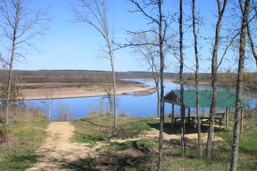
Tyrone’s Trail and Overlook is a scenic stop on the Chippewa River Trail
Chippewa River State Trail
If bicycling is a passion, the Chippewa River Trail is a required destination. This 30-mile trail runs along the Chippewa River from Phoenix Park in downtown Eau Claire to Durand. The trail is also popular with walkers and closer to Eau Claire, in-line skaters, Trail users will pass through a variety of habitat types including hardwood river bottoms, prairies, wetlands, and urban and farm fields. Limestone rock formations and scenic views of the Chippewa River are highlights of this trail. Numerous birds and other wildlife inhabit the land surrounding the trails. Wildlife viewing is always the best early in the morning or as sunset is approaching. The section of the river and trail from Carryville to Meridean is perfect for a “Surf n Turf” trip where people paddle from Carryville to Meridean and then ride their bikes back to Carryville. The Tyrone’s Trail and Overlook which is 1.5 miles north of the intersection of the Red Cedar Trail and the Chippewa River Trail has a nice picnic shelter and a very scenic view of the river. It's the perfect spot for rest and refreshment when riding or walking the trail. The trail has multiple access points besides the two trailheads. Access points are located at Phoenix Park, Highway 85, Carryville, Meridean, Dunnville Bottoms-at the junction of the Red Cedar Trail and the Chippewa Trail, and Tarrant Park in Durand. Maps of both the Chippewa River Trail and the Old Abe Trail can be found here Trail map [PDF]
August is a great time for summer adventures. This list of adventures is a just the tip of the iceberg for outdoor fun in Western Wisconsin. Get the family organized or round up a group of friends, pack your gear, fire up the GPS, and go adventuring to create memories that will last a lifetime.
Memberships

Add new comment